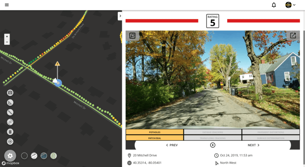
Pittsburgh, PA, February 5, 2020 – RoadBotics has announced a groundbreaking option to complement its interactive, online pavement assessment platform, RoadWay, that identifies common distresses like potholes, surface deterioration, and fatigue cracking. This first-of-its-kind functionality allows users to view these distresses in every 10-foot section of road on a pothole-specific layer that can be seen in conjunction with a color-coded map of their entire network.
With Individual Distress Identification on RoadWay, users can strategically plan for treatment of existing problems and proactively manage maintenance to save their town or city time and resources – not to mention clearly communicate the condition of their road network to their staff, local government officials, and citizens.
“The new ability to identify distresses makes RoadWay the most robust tool our clients have to make data-driven decisions about their road network,” said RoadBotics Head of Product, Matt Lucas. “This critical and actionable data gives them a more comprehensive perspective, allowing them to create efficient management plans.”
RoadBotics, whose pavement assessment process is unique because it only requires a smartphone for data collection unlike pricier van scans or time-intense manual audits, can now identify 18 different distresses that fall into six categories that are critical to pavement management including potholes, surface issues, and fatigue issues.
“The ability to identify these distresses is another major advance that RoadBotics has taken to make affordable and objective infrastructure assessments a reality to every community in the world,” said RoadBotics President and Co-Founder, Benjamin Schmidt, PhD.
Distress Identification was released as a part of RoadBotics’ RoadWay platform in early February. Monthly updates and releases to the platform are a part of RoadBotics continuous efforts for improvement, and feedback from current clients has been instrumental to the development of RoadWay since its inception.
About RoadBotics:
RoadBotics empowers towns and cities to make objective, data-driven decisions about their roads and infrastructure. We automate inspections and generate actionable data about road networks. Our detailed maps, unbiased ratings, and practical tools save time and taxpayer dollars for hundreds of communities across the country and around the world.
RoadWay is our interactive cloud-based online platform where you can view, assess, and manage your road network conditions, including the identification of common distresses like potholes and alligator cracking. Whether you are at your desk or out in the field, RoadWay’s detailed maps and practical tools make analyzing your network and prioritizing maintenance easier than ever before.
RoadBotics was spun out of Pittsburgh’s Carnegie Mellon’s Robotics Institute in 2016 and has raised $11.4M in venture capital investment to date. We envision applying our technology to not only improve the world’s roads, but also the critical infrastructure that impacts people’s lives every day.
###
For more information, please reach out at marketing@roadbotics.com.