RoadWay Logo

Visualize and analyze your roads with ratings generated by artificial intelligence

Meet RoadWay

Manual assessments waste valuable man hours and result in subjective ratings, while expensive van scans generate overwhelming amounts of data. 

Both methods make it difficult to create pavement maintenance and management plans. 

RoadWay empowers communities to make objective, data-driven decisions about their road networks by automating their inspections and generating actionable data with our technology.

What we provide

Our detailed maps, unbiased ratings, and practical tools save time and taxpayer dollars for
hundreds of communities across the country and around the world.

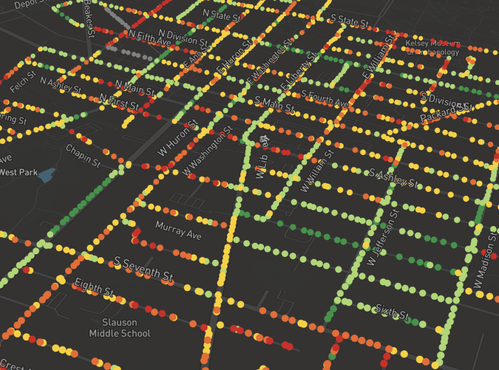
Useful Pavement Condition Data

Ratings are compiled and available in a CSV file that can be sorted and filtered to create pavement management strategies.

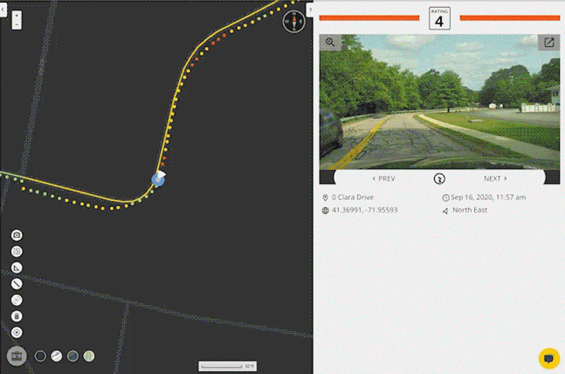
Vivid Imagery with Metadata

Point-level, 1080p high-definition images are taken of each section of road, complete with GIS location details and timestamp.

Navigate Your Roads from Your Desk

Drive down your road network and make data-driven decisions right from your desktop.

Customer Experience Expert at Your Service

Dedicated RoadBotics Experts are always available to answer questions, provide training, or accept feedback.

flag icon

Satisfied Clients Around the World

We serve over 250 governments and 30 engineering firms in the US - plus many more worldwide.

Start the Process

Collect Visual Data

Using your smartphone, GoPro, 360 camera, or drone footage, collect visual data of the roads you’d like to have rated. 

The imagery you collect will immediately appear on RoadWay, allowing you to easily see what’s been covered and what still needs collected. 

Let AI Do the Work

Your road imagery is then fed through our artificial intelligence (AI) algorithms.

RoadBotics by Michelin technology is built on years of advanced research and development, and our algorithms have been precisely tuned to deliver objective and actionable data.

Analyze Your Results

Your imagery and ratings are mapped on RoadWay, our interactive online platform.

Views can be customized to gain the insight needed to create preventative maintenance and construction plans. 

FEATURES

Virtually Drive Your Network Any Time

Take a ride down any part of your road network whenever and wherever you’d like using the Virtual Driver feature. 

View street-adjacent assets, confirm reports, and evaluate conditions from your desk. 

Use Your Toolbox

Make the most of your RoadWay experience with tools that can quickly: 

  • Measure the area and distance of anything on your map – like a driveway, sidewalk, or intersection
  • Select a section of your assessment to summarize results for –  for example, a neighborhood or business district
  • Adjust your views and perspectives based on your preferences

Share with Your Community

Increase transparency with your community or colleagues by sharing your results on a website.

The Embedded Maps function generates a few lines of code that can be copied and pasted into any web page, allowing you to share an interactive map of your road network.  

Click into the map to navigate the assessment. 

Ready to Get Started?

Contact us or set up a demo now!