


Are you wasting time conducting manual pavement assessments?
When it comes to being part of a local government team, there is no shortage of tasks to complete. With the American Society of Civil Engineers rating the US’s roads as a “D,” Public Works teams have their work cut out for them!
Juggling fluctuating budgets, staff, and seasonal needs daily doesn’t leave much time to stop and ask:
“Are there any easy opportunities for improvement?”
If you’re still conducting manual pavement condition assessments, the answer is YES.
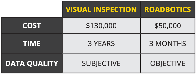
In many regions, a pavement management strategy begins with assessing every road in a network. Mainstream methods of evaluating an entire road network revolve around manually inspecting each road over many months from inside of a vehicle. Depending on how many miles of road your network contains, this could take anywhere from three months up to a year to complete.
Public Works teams know that much time is hard to spare. Instead of finding a faster method, they often reduce the frequency of assessments to every 3, 4, or even 5 years. While this might save time, it decreases the relevance of the data they are collecting and creates openings for inefficiency during maintenance planning.
In addition to long turnaround times, manual assessments are subject to factors like availability, experience, and mood of the person performing them. The combination of time and human error impacts when and how well these assessments are conducted.
In short, communities can invest a lot of time AND tax-payer dollars on a process that isn’t delivering the most bang for their buck.
What’s the alternative?
After working with over 250 communities, RoadBotics by Michelin has seen how automating road assessments reduced the time needed to assess a road network, resulting in enormous time savings and useful, objective data.
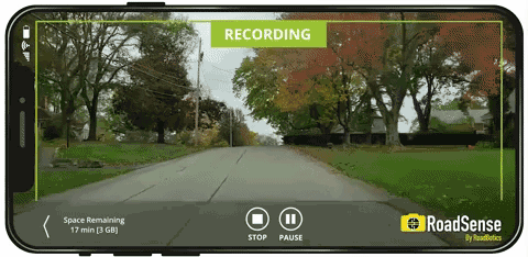
Our assessments start with a blueprinting process that outlines the fastest route to collect data for all of your roads. Then, any individual with a smartphone mounted in the windshield can follow the route as the RoadSense app collects high-definition video data. In the right conditions, collection can be completed over a short period of time – days or weeks rather than weeks or months.
After collection is complete, our proprietary computer vision algorithm analyzes every 10-foot section of road using artificial intelligence (AI). Fortunately, AI never experiences tiredness, hunger, or decision fatigue, so its results are unbiased and consistent.
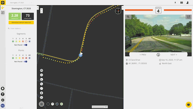
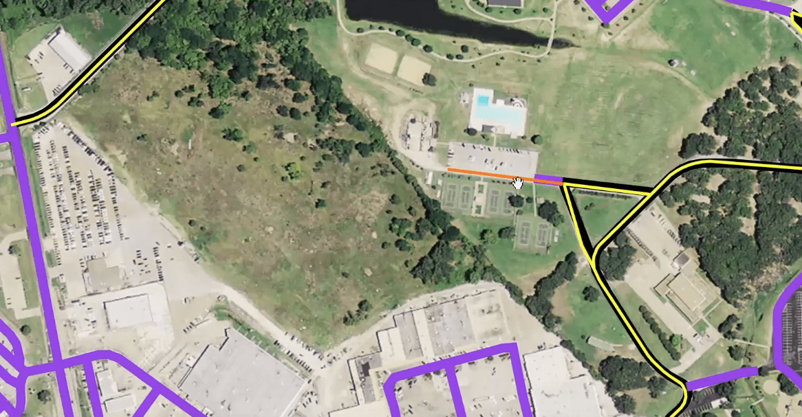
Color-coded ratings on a scale of 1-5, with 1 being the best condition and 5 being the worst, are delivered on an interactive map. In addition, spreadsheet data that is able to be integrated with other systems is also provided.
Automation saves considerable time. We helped the City of Savannah, Georgia, complete a road assessment in three months, when it had previously taken an entire year. A smaller community – Bethel Park, Pennsylvania – was able to reduce their assessment process time from two weeks to one day.
Automation also allows assessments to be conducted more frequently – which is useful for regions that experience recurring freeze/thaw cycles. Planning becomes more streamlined with multiple assessments, as seen in Dublin, Ohio’s adoption of our technology. For communities like Peters Township, Pennsylvania, the year-over-year time savings were most apparent in the analysis process. Our spreadsheet data served as an objective reference to help speed up their pavement maintenance planning.
Does it take a lot of effort to switch to an automated road assessment process?
Implementing an automated pavement assessment process is simple.
Dublin’s Director of Asset Management & Support Services, Robert J. Taylor, PE, shared that “RoadBotics has provided Dublin with simplistic, easily digestible pavement data.”
With so many people relying on roads every day, it is hard to justify processes that aren’t producing the best results.
Heath Lloyd, Savannah’s Chief Infrastructure and Development Officer put it best, “This partnership with RoadBotics will allow us to better assess the overall condition of city roadways and increase the accuracy of the data collected. It ultimately allows us to be more effective in managing the replacement of our infrastructure. Our goal is to use our resources in the most efficient manner possible. RoadBotics helps us accomplish that goal by enhancing our ability to better plan and implement city-wide roadway replacement schedules”.

© 2023 RoadBotics, Inc | 322 North Shore Drive, Suite 200, Pittsburgh, PA 15212
| Cookie | Duration | Description |
|---|---|---|
| __hssrc | session | This cookie is set by Hubspot whenever it changes the session cookie. The __hssrc cookie set to 1 indicates that the user has restarted the browser, and if the cookie does not exist, it is assumed to be a new session. |
| _GRECAPTCHA | 5 months 27 days | This cookie is set by the Google recaptcha service to identify bots to protect the website against malicious spam attacks. |
| ak_bmsc | 2 hours | This cookie is used by Akamai to optimize site security by distinguishing between humans and bots |
| citrix_ns_id | session | This cookie is set by the provider Citrix, a web application firewall. This cookie is used for protecting the website against known and unknown attacks. |
| cookielawinfo-checkbox-advertisement | 1 year | Set by the GDPR Cookie Consent plugin, this cookie is used to record the user consent for the cookies in the "Advertisement" category . |
| cookielawinfo-checkbox-analytics | 1 year | Set by the GDPR Cookie Consent plugin, this cookie is used to record the user consent for the cookies in the "Analytics" category . |
| cookielawinfo-checkbox-functional | 1 year | The cookie is set by the GDPR Cookie Consent plugin to record the user consent for the cookies in the category "Functional". |
| cookielawinfo-checkbox-necessary | 1 year | Set by the GDPR Cookie Consent plugin, this cookie is used to record the user consent for the cookies in the "Necessary" category . |
| cookielawinfo-checkbox-others | 1 year | Set by the GDPR Cookie Consent plugin, this cookie is used to store the user consent for cookies in the category "Others". |
| cookielawinfo-checkbox-performance | 1 year | Set by the GDPR Cookie Consent plugin, this cookie is used to store the user consent for cookies in the category "Performance". |
| CookieLawInfoConsent | 1 year | Records the default button state of the corresponding category & the status of CCPA. It works only in coordination with the primary cookie. |
| elementor | never | This cookie is used by the website's WordPress theme. It allows the website owner to implement or change the website's content in real-time. |
| JSESSIONID | session | The JSESSIONID cookie is used by New Relic to store a session identifier so that New Relic can monitor session counts for an application. |
| viewed_cookie_policy | 1 year | The cookie is set by the GDPR Cookie Consent plugin to store whether or not the user has consented to the use of cookies. It does not store any personal data. |
| Cookie | Duration | Description |
|---|---|---|
| A3 | 1 year | No description |
| AnalyticsSyncHistory | 1 month | No description |
| citrix_ns_id_.d2d.gsa.gov__wlf | session | No description |
| citrix_ns_id_.gsa.gov__wlf | session | No description |
| li_gc | 5 months 27 days | No description |
| ln_or | 1 day | No description |
| m | 2 years | No description available. |
| NSC_IUUQ-Ebub2Efd | session | No description |
| SSESSe6f64672c023222bafbc47f83a5ecbd4 | 23 days 4 hours | No description |
| TS01c2db25 | session | No description |
| Cookie | Duration | Description |
|---|---|---|
| _fbp | 3 months | This cookie is set by Facebook to display advertisements when either on Facebook or on a digital platform powered by Facebook advertising, after visiting the website. |
| c | 1 year | This cookie is set by Rubicon Project to control synchronization of user identification and exchange of user data between various ad services. |
| CONSENT | 2 years | YouTube sets this cookie via embedded youtube-videos and registers anonymous statistical data. |
| fr | 3 months | Facebook sets this cookie to show relevant advertisements to users by tracking user behaviour across the web, on sites that have Facebook pixel or Facebook social plugin. |
| IDE | 1 year 24 days | Google DoubleClick IDE cookies are used to store information about how the user uses the website to present them with relevant ads and according to the user profile. |
| test_cookie | 15 minutes | The test_cookie is set by doubleclick.net and is used to determine if the user's browser supports cookies. |
| tuuid | 1 year | The tuuid cookie, set by BidSwitch, stores an unique ID to determine what adverts the users have seen if they have visited any of the advertiser's websites. The information is used to decide when and how often users will see a certain banner. |
| tuuid_lu | 1 year | This cookie, set by BidSwitch, stores a unique ID to determine what adverts the users have seen while visiting an advertiser's website. This information is then used to understand when and how often users will see a certain banner. |
| VISITOR_INFO1_LIVE | 5 months 27 days | A cookie set by YouTube to measure bandwidth that determines whether the user gets the new or old player interface. |
| YSC | session | YSC cookie is set by Youtube and is used to track the views of embedded videos on Youtube pages. |
| yt-remote-connected-devices | never | YouTube sets this cookie to store the video preferences of the user using embedded YouTube video. |
| yt-remote-device-id | never | YouTube sets this cookie to store the video preferences of the user using embedded YouTube video. |
| yt.innertube::nextId | never | This cookie, set by YouTube, registers a unique ID to store data on what videos from YouTube the user has seen. |
| yt.innertube::requests | never | This cookie, set by YouTube, registers a unique ID to store data on what videos from YouTube the user has seen. |
| Cookie | Duration | Description |
|---|---|---|
| __hstc | 5 months 27 days | This is the main cookie set by Hubspot, for tracking visitors. It contains the domain, initial timestamp (first visit), last timestamp (last visit), current timestamp (this visit), and session number (increments for each subsequent session). |
| _ga | 2 years | The _ga cookie, installed by Google Analytics, calculates visitor, session and campaign data and also keeps track of site usage for the site's analytics report. The cookie stores information anonymously and assigns a randomly generated number to recognize unique visitors. |
| _ga_SQVZMMXYCW | 2 years | This cookie is installed by Google Analytics. |
| _gat_gtag_UA_88652169_15 | 1 minute | Set by Google to distinguish users. |
| _gat_UA-88652169-1 | 1 minute | A variation of the _gat cookie set by Google Analytics and Google Tag Manager to allow website owners to track visitor behaviour and measure site performance. The pattern element in the name contains the unique identity number of the account or website it relates to. |
| _gcl_au | 3 months | Provided by Google Tag Manager to experiment advertisement efficiency of websites using their services. |
| _gid | 1 day | Installed by Google Analytics, _gid cookie stores information on how visitors use a website, while also creating an analytics report of the website's performance. Some of the data that are collected include the number of visitors, their source, and the pages they visit anonymously. |
| hubspotutk | 5 months 27 days | HubSpot sets this cookie to keep track of the visitors to the website. This cookie is passed to HubSpot on form submission and used when deduplicating contacts. |
| Cookie | Duration | Description |
|---|---|---|
| __cf_bm | 30 minutes | This cookie, set by Cloudflare, is used to support Cloudflare Bot Management. |
| __hssc | 30 minutes | HubSpot sets this cookie to keep track of sessions and to determine if HubSpot should increment the session number and timestamps in the __hstc cookie. |
| bcookie | 1 year | LinkedIn sets this cookie from LinkedIn share buttons and ad tags to recognize browser ID. |
| bscookie | 1 year | LinkedIn sets this cookie to store performed actions on the website. |
| lang | session | LinkedIn sets this cookie to remember a user's language setting. |
| lidc | 1 day | LinkedIn sets the lidc cookie to facilitate data center selection. |
| messagesUtk | 5 months 27 days | HubSpot sets this cookie to recognize visitors who chat via the chatflows tool. |
| tads_uid | 5 years | The domain of this cookie is owned by Technorati.This cookie helps the user to share pages through social networking sites. The main purpose of this cookie is advertising. |
| UserMatchHistory | 1 month | LinkedIn sets this cookie for LinkedIn Ads ID syncing. |


