


If you are part of a Public Works team or engineering firm that manages roads, how do you determine if your maintenance efforts are successful year over year?
With March marking the start of the paving season for many regions across the US, spring is the perfect time to consider if your current methods could use some improvement.
Follow along as we share how to enhance your current road maintenance planning by reviewing your methods, researching the best tools, and implementing strategies that incorporate objective data.
When it comes to the roads you manage, can you answer questions like:
When was the last time every road in the network was assessed?
What was the condition and location of the worst roads? The best?
What percentage of roads were mid-quality, and how will their quality be preserved with preventative maintenance treatments?
Do you operate on a reactive or preventative road maintenance system?
Questions like these provide the basis for better road maintenance – knowing the best route to achieve your goals begins with having a clear understanding of where you’re starting.
Once you review all the components of your current system, it’s time to identify gaps. As with any gap analysis, prioritization is key to setting yourself up for long-term success.
Gaps in road maintenance strategies can range from very high-level to more granular in nature.
For starters, if you don’t have an objective, high-level overview of every road in your network, this is where it makes the most sense to begin. Without it, decisions surrounding which roads to repave and when can become more subjective, leading to higher costs and worse roads.
Once you have established an objective overview, more granular gaps can be prioritized, like which roads need sealing treatment versus patching.
Once you have a gap in mind you’d like to improve, you’re ready to move on to the research phase.
In working with over 300 communities, we have found that technology-based tools are the most effective for streamlining time-consuming or repetitive tasks.
Many new technology tools promise to solve all of your challenges. The trick is to find the tool that matches your needs that has the right features and falls within your budget.
Technology can support common road maintenance challenges in a few different ways, especially when it comes to the road assessment process.
When picking the best technology tool for the job, it can be helpful to think critically about your main goals. If you were looking to improve your road assessment process, it would be helpful to consider topics like:
Road Assessment Data Collection Process
Does this tool help me to standardize my road assessments or make them easier to complete?
Frequency of Assessment
Does this tool allow me to conduct assessments in less time or with greater frequency?
Data “Usability”
Does this tool allow me to view my data in a useful way? Can I make actionable decisions about road maintenance with this tool?
In comparing some commonly used road assessment methods, we can see which makes use of technology tools and how that impacts common gaps.
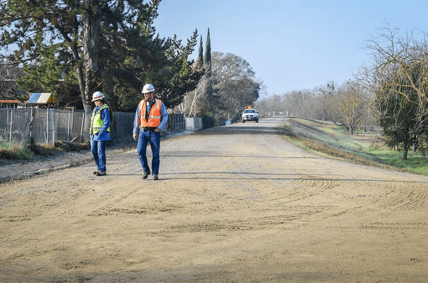
Manual methods like windshield surveys typically rely more on professional experience than technology. This mainstream method relies on low-cost technology like spreadsheets, and has a lower barrier to entry. But, the data quality can be influenced by human error and staff availability, indirectly impacting other important areas like assessment frequency and objective decision-making.
Mobile LiDAR systems are a technology-based assessment method that uses light-detecting lasers to collect road condition information. This delivers quicker and more objective assessments but comes with a high entry cost. To get started, communities must purchase LiDAR scanners or prefabricated LiDAR vans. In addition, opting for this technology requires additional steps to clean, analyze, and visualize the results before they can be used for planning maintenance.
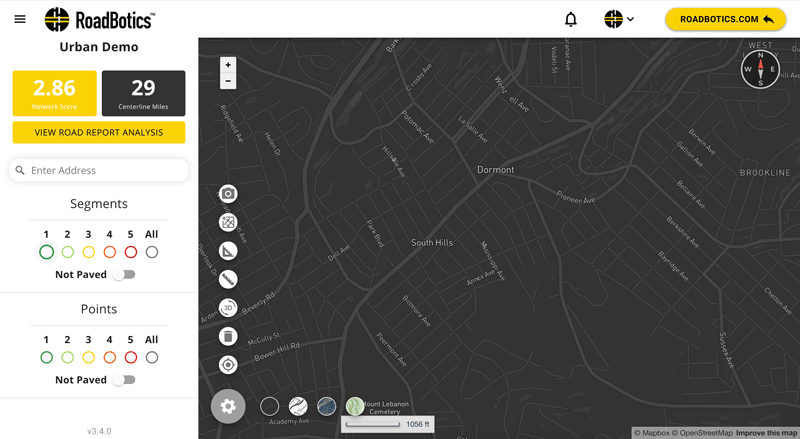
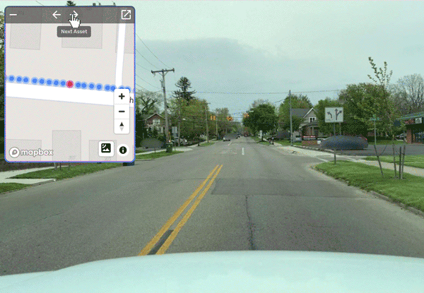
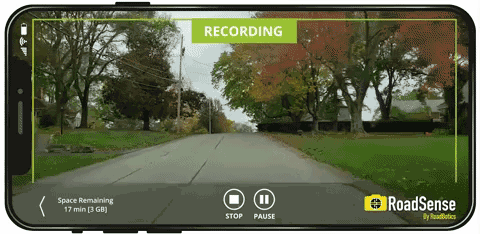
Automated road assessment software can provide a middle ground between manual and LiDAR-based assessments. This method offers the ability to collect road data with a smartphone and provides AI-generated road condition ratings.
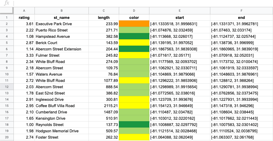
All the objective data is automatically visualized on a color-coded, interactive map, making tasks like identifying the worst or best roads easy.
Results are able to be exported in CSV or Shapefile formats to integrate across systems.
The funds you have available, time you’re looking to commit, and data quality you’re seeking will impact which tool is the best fit to bridge your gaps.
After you choose the best technology tool for your assessment, it’s time to put it to the test!
Once you’ve picked which new technology to integrate, it’s time to see what it can do and compare the results to your previous method.
If you have a particular metric you identified in Step 1, then it is pretty straightforward to gauge success – Take a look at the past few years’ data and calculate how the new results differ.
If you’re looking for a more comprehensive view of performance, it can be helpful to reference quantitative and qualitative data.
You can collect more qualitative data, like surveys, from staff regarding the time spent and ease of use. This information is valuable in determining if a new technology tool will be well received long term.
In terms of proving ROI, quantitative data is more practical. Assessing time, cost, and quality from a numerical perspective requires unbiased objectivity. Typically, this is machine-generated, or additional measures are taken to limit subjective bias. As it related to road maintenance efforts, you could calculate and compare time spent, labor used, and road condition change. This data is most accurate using LiDAR scans or automated road assessment systems.
After reviewing, researching, and implementing, you’re now on your way to better road maintenance! The best part is that this simple approach can be referenced repeatedly to assess rather than guess if something is worth the investment.
If you identified the need for a more objective approach to road assessments, we recommend downloading our FREE Road Assessments guide for Local Government and Small Teams to learn how automated road assessments work and what benefits they have to offer.

© 2023 RoadBotics, Inc | 322 North Shore Drive, Suite 200, Pittsburgh, PA 15212
| Cookie | Duration | Description |
|---|---|---|
| __hssrc | session | This cookie is set by Hubspot whenever it changes the session cookie. The __hssrc cookie set to 1 indicates that the user has restarted the browser, and if the cookie does not exist, it is assumed to be a new session. |
| _GRECAPTCHA | 5 months 27 days | This cookie is set by the Google recaptcha service to identify bots to protect the website against malicious spam attacks. |
| ak_bmsc | 2 hours | This cookie is used by Akamai to optimize site security by distinguishing between humans and bots |
| citrix_ns_id | session | This cookie is set by the provider Citrix, a web application firewall. This cookie is used for protecting the website against known and unknown attacks. |
| cookielawinfo-checkbox-advertisement | 1 year | Set by the GDPR Cookie Consent plugin, this cookie is used to record the user consent for the cookies in the "Advertisement" category . |
| cookielawinfo-checkbox-analytics | 1 year | Set by the GDPR Cookie Consent plugin, this cookie is used to record the user consent for the cookies in the "Analytics" category . |
| cookielawinfo-checkbox-functional | 1 year | The cookie is set by the GDPR Cookie Consent plugin to record the user consent for the cookies in the category "Functional". |
| cookielawinfo-checkbox-necessary | 1 year | Set by the GDPR Cookie Consent plugin, this cookie is used to record the user consent for the cookies in the "Necessary" category . |
| cookielawinfo-checkbox-others | 1 year | Set by the GDPR Cookie Consent plugin, this cookie is used to store the user consent for cookies in the category "Others". |
| cookielawinfo-checkbox-performance | 1 year | Set by the GDPR Cookie Consent plugin, this cookie is used to store the user consent for cookies in the category "Performance". |
| CookieLawInfoConsent | 1 year | Records the default button state of the corresponding category & the status of CCPA. It works only in coordination with the primary cookie. |
| elementor | never | This cookie is used by the website's WordPress theme. It allows the website owner to implement or change the website's content in real-time. |
| JSESSIONID | session | The JSESSIONID cookie is used by New Relic to store a session identifier so that New Relic can monitor session counts for an application. |
| viewed_cookie_policy | 1 year | The cookie is set by the GDPR Cookie Consent plugin to store whether or not the user has consented to the use of cookies. It does not store any personal data. |
| Cookie | Duration | Description |
|---|---|---|
| A3 | 1 year | No description |
| AnalyticsSyncHistory | 1 month | No description |
| citrix_ns_id_.d2d.gsa.gov__wlf | session | No description |
| citrix_ns_id_.gsa.gov__wlf | session | No description |
| li_gc | 5 months 27 days | No description |
| ln_or | 1 day | No description |
| m | 2 years | No description available. |
| NSC_IUUQ-Ebub2Efd | session | No description |
| SSESSe6f64672c023222bafbc47f83a5ecbd4 | 23 days 4 hours | No description |
| TS01c2db25 | session | No description |
| Cookie | Duration | Description |
|---|---|---|
| _fbp | 3 months | This cookie is set by Facebook to display advertisements when either on Facebook or on a digital platform powered by Facebook advertising, after visiting the website. |
| c | 1 year | This cookie is set by Rubicon Project to control synchronization of user identification and exchange of user data between various ad services. |
| CONSENT | 2 years | YouTube sets this cookie via embedded youtube-videos and registers anonymous statistical data. |
| fr | 3 months | Facebook sets this cookie to show relevant advertisements to users by tracking user behaviour across the web, on sites that have Facebook pixel or Facebook social plugin. |
| IDE | 1 year 24 days | Google DoubleClick IDE cookies are used to store information about how the user uses the website to present them with relevant ads and according to the user profile. |
| test_cookie | 15 minutes | The test_cookie is set by doubleclick.net and is used to determine if the user's browser supports cookies. |
| tuuid | 1 year | The tuuid cookie, set by BidSwitch, stores an unique ID to determine what adverts the users have seen if they have visited any of the advertiser's websites. The information is used to decide when and how often users will see a certain banner. |
| tuuid_lu | 1 year | This cookie, set by BidSwitch, stores a unique ID to determine what adverts the users have seen while visiting an advertiser's website. This information is then used to understand when and how often users will see a certain banner. |
| VISITOR_INFO1_LIVE | 5 months 27 days | A cookie set by YouTube to measure bandwidth that determines whether the user gets the new or old player interface. |
| YSC | session | YSC cookie is set by Youtube and is used to track the views of embedded videos on Youtube pages. |
| yt-remote-connected-devices | never | YouTube sets this cookie to store the video preferences of the user using embedded YouTube video. |
| yt-remote-device-id | never | YouTube sets this cookie to store the video preferences of the user using embedded YouTube video. |
| yt.innertube::nextId | never | This cookie, set by YouTube, registers a unique ID to store data on what videos from YouTube the user has seen. |
| yt.innertube::requests | never | This cookie, set by YouTube, registers a unique ID to store data on what videos from YouTube the user has seen. |
| Cookie | Duration | Description |
|---|---|---|
| __hstc | 5 months 27 days | This is the main cookie set by Hubspot, for tracking visitors. It contains the domain, initial timestamp (first visit), last timestamp (last visit), current timestamp (this visit), and session number (increments for each subsequent session). |
| _ga | 2 years | The _ga cookie, installed by Google Analytics, calculates visitor, session and campaign data and also keeps track of site usage for the site's analytics report. The cookie stores information anonymously and assigns a randomly generated number to recognize unique visitors. |
| _ga_SQVZMMXYCW | 2 years | This cookie is installed by Google Analytics. |
| _gat_gtag_UA_88652169_15 | 1 minute | Set by Google to distinguish users. |
| _gat_UA-88652169-1 | 1 minute | A variation of the _gat cookie set by Google Analytics and Google Tag Manager to allow website owners to track visitor behaviour and measure site performance. The pattern element in the name contains the unique identity number of the account or website it relates to. |
| _gcl_au | 3 months | Provided by Google Tag Manager to experiment advertisement efficiency of websites using their services. |
| _gid | 1 day | Installed by Google Analytics, _gid cookie stores information on how visitors use a website, while also creating an analytics report of the website's performance. Some of the data that are collected include the number of visitors, their source, and the pages they visit anonymously. |
| hubspotutk | 5 months 27 days | HubSpot sets this cookie to keep track of the visitors to the website. This cookie is passed to HubSpot on form submission and used when deduplicating contacts. |
| Cookie | Duration | Description |
|---|---|---|
| __cf_bm | 30 minutes | This cookie, set by Cloudflare, is used to support Cloudflare Bot Management. |
| __hssc | 30 minutes | HubSpot sets this cookie to keep track of sessions and to determine if HubSpot should increment the session number and timestamps in the __hstc cookie. |
| bcookie | 1 year | LinkedIn sets this cookie from LinkedIn share buttons and ad tags to recognize browser ID. |
| bscookie | 1 year | LinkedIn sets this cookie to store performed actions on the website. |
| lang | session | LinkedIn sets this cookie to remember a user's language setting. |
| lidc | 1 day | LinkedIn sets the lidc cookie to facilitate data center selection. |
| messagesUtk | 5 months 27 days | HubSpot sets this cookie to recognize visitors who chat via the chatflows tool. |
| tads_uid | 5 years | The domain of this cookie is owned by Technorati.This cookie helps the user to share pages through social networking sites. The main purpose of this cookie is advertising. |
| UserMatchHistory | 1 month | LinkedIn sets this cookie for LinkedIn Ads ID syncing. |


