
The recently-released RoadBotics U.S. City Roads Report took a close look at road conditions in 20 major metropolitan cities.
Luckily, our unique approach to data collection using a smartphone mounted to the windshield of a vehicle not only revealed the road conditions in those cities, but also captured local sites including city parks, historical landmarks, and even baseball stadiums.
In the last article of the Uncovered on the U.S. City Roads Report series, let’s find historical landmarks on RoadWay!
The fourth of July, or Independence Day, is a national holiday marking the signing of the Declaration of Independence in 1776. Where did that take place?
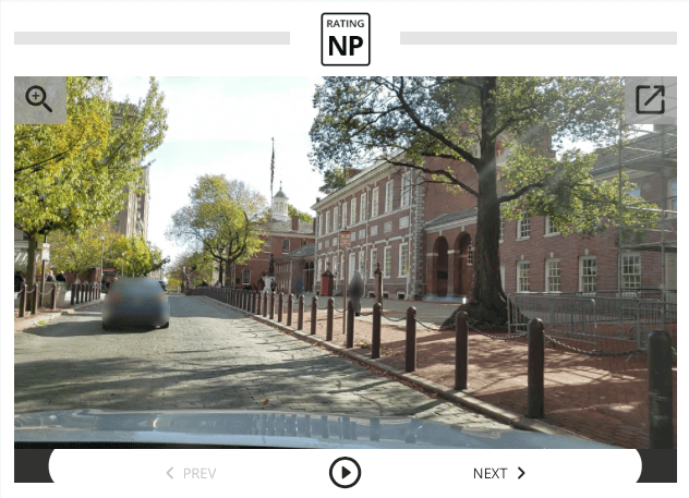
Independence Hall, of course!
Independence Hall, located in Philadelphia, is not only the site of one momentous event, but two! Eleven years later, in 1787, the Constitutional Convention drafted and signed the U.S. Constitution in the exact same room as the Declaration of Independence.
This beautiful brick beacon of American freedom and democracy is located on Chestnut Street, between 5th Street and 23rd Street, and is in ‘Good’ condition with a RoadBotics rating of 2.08.
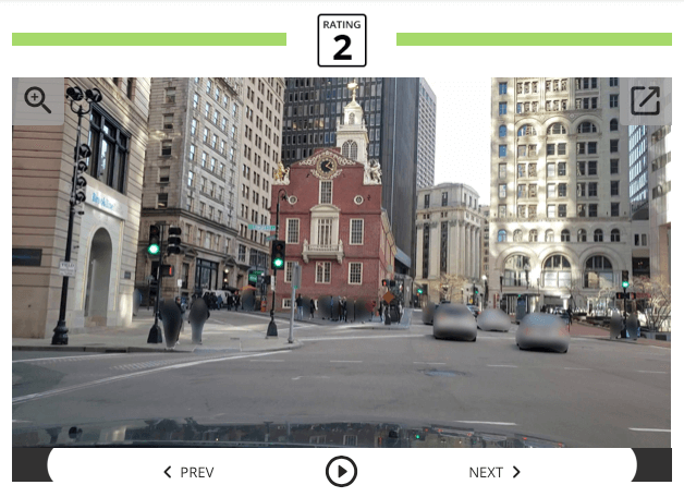
Built in 1713, the Old State House is one of the oldest public buildings in the United States and the oldest in Boston. Upon completion, the first floor was used for merchant trading, and the second floor housed the British sovereign appointed governor.
In 1770, the Old State House was the location of the bloody Boston Massacre that left five people dead and many others injured. British sentry and soldiers open fired on a group of Bostonians who came to the defense of local boys who had been assaulted by the sentry.
Six years later, more shots were fired outside of the Old State House, this time in celebration of the Declaration of Independence!
Old State House is located between Washington and State Streets. The average RoadBotics rating for the 1,500-foot long State Street is 2.09, or ‘Good’ condition.
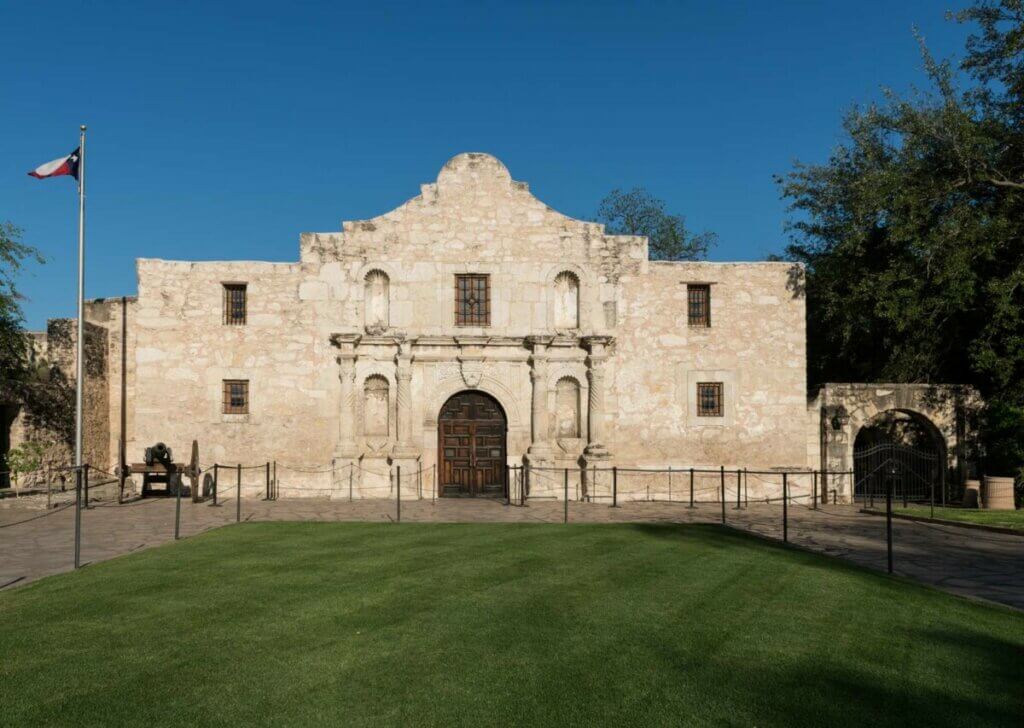
What began as a Franciscan mission soon became the Texas state symbol for resilience. The Alamo, named after the surrounding cottonwood trees, was the site of defense against the Mexican Army.
In 1836, nearly 200 Texan volunteers held their position for 13 days within the Alamo, defending against a Mexican Troop of an estimated 1,800-6,000 soldiers. Despite their efforts, the defenders eventually fell to the Mexican Army. However, their heroic efforts became a symbol of courage and resilience during the Battle of San Jacinto and the Mexican-American War.
Due to stone walls around the Alamo Historical site, RoadWay was not able to catch a glimpse of the structure. But, the roads surrounding the Alamo site have a ‘Good’ RoadBotics rating of 2.12.
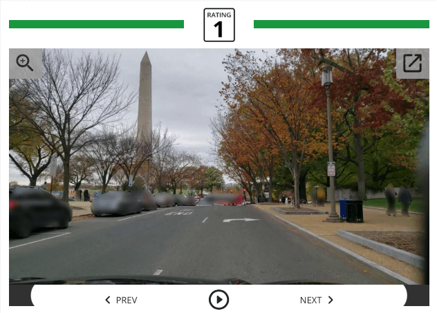
“First in War, First in Peace, and First in the hearts of his countrymen.” -Henry Lee, George Washinton’s eulogy.
The Washington Monument stands proudly in the center of Washington, D.C., and was constructed to commemorate America’s first President and fearless leader. It was constructed in two phases and upon its completion in 1884, it was the tallest building in the world standing at just over 555 feet.
The Washington Monument’s symbolic Egyptian obelisk shape can be seen from many parts of the city. The roads surrounding the monument and its grounds are in ‘Fair’ condition with a RoadBotics rating of 2.46.
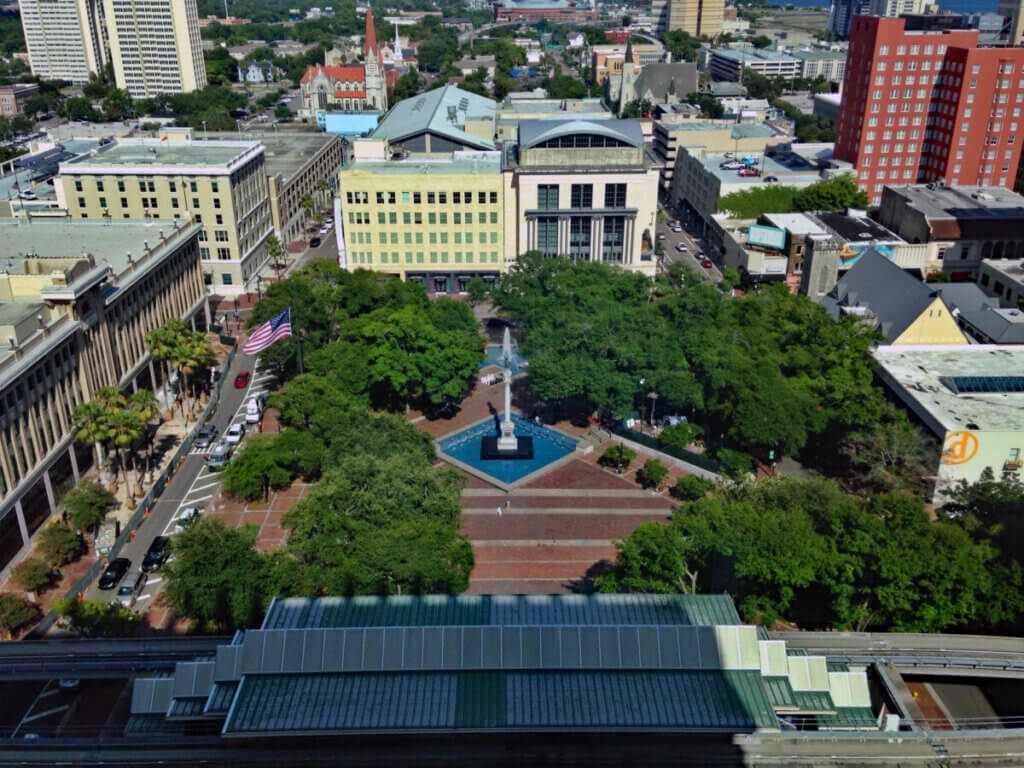
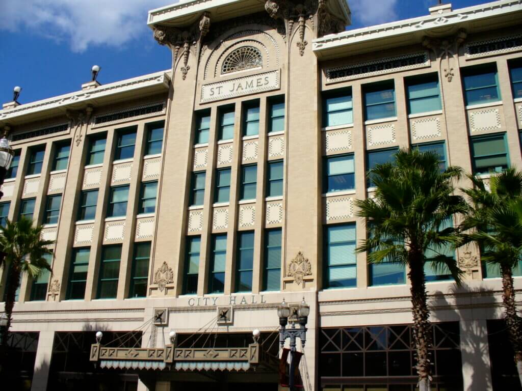
Situated right across the street from one another in downtown Jacksonville are St. James Building and James Weldon Johnson Park.
St. James Building was constructed in 1912 by architect Henry John Klutho. It was originally built as a hotel, then became a department store, and is now Jacksonville City Hall.
In the hotel’s heyday, over 65,000 tourists visited Jacksonville each summer, many of which spent their time at the hotel’s entertainment scene and the park across the street. The park was so popular that the once-named ‘City Park’ became known as ‘St. James Park.’ That same popular public square is now called James Weldon Johnson Park.
The RoadWay image captures St. James Building on the right and the trees that line James Weldon Johnson Park on the left. The roads surrounding the plaza, West Duval Street, Hogan Street, Monroe Street West, and Laura Street North, are in ‘Excellent’ condition with a RoadBotics rating of 1.64.
Want to learn more about RoadBotics U.S. City Roads Report? See the report in its entirety. Read insight around the report from our CEO Ben Schmidt, Ph.D. Watch interviews with Infrastructure Leaders about what innovation they think has had the most impact.

© 2023 RoadBotics, Inc | 322 North Shore Drive, Suite 200, Pittsburgh, PA 15212
| Cookie | Duration | Description |
|---|---|---|
| __hssrc | session | This cookie is set by Hubspot whenever it changes the session cookie. The __hssrc cookie set to 1 indicates that the user has restarted the browser, and if the cookie does not exist, it is assumed to be a new session. |
| _GRECAPTCHA | 5 months 27 days | This cookie is set by the Google recaptcha service to identify bots to protect the website against malicious spam attacks. |
| ak_bmsc | 2 hours | This cookie is used by Akamai to optimize site security by distinguishing between humans and bots |
| citrix_ns_id | session | This cookie is set by the provider Citrix, a web application firewall. This cookie is used for protecting the website against known and unknown attacks. |
| cookielawinfo-checkbox-advertisement | 1 year | Set by the GDPR Cookie Consent plugin, this cookie is used to record the user consent for the cookies in the "Advertisement" category . |
| cookielawinfo-checkbox-analytics | 1 year | Set by the GDPR Cookie Consent plugin, this cookie is used to record the user consent for the cookies in the "Analytics" category . |
| cookielawinfo-checkbox-functional | 1 year | The cookie is set by the GDPR Cookie Consent plugin to record the user consent for the cookies in the category "Functional". |
| cookielawinfo-checkbox-necessary | 1 year | Set by the GDPR Cookie Consent plugin, this cookie is used to record the user consent for the cookies in the "Necessary" category . |
| cookielawinfo-checkbox-others | 1 year | Set by the GDPR Cookie Consent plugin, this cookie is used to store the user consent for cookies in the category "Others". |
| cookielawinfo-checkbox-performance | 1 year | Set by the GDPR Cookie Consent plugin, this cookie is used to store the user consent for cookies in the category "Performance". |
| CookieLawInfoConsent | 1 year | Records the default button state of the corresponding category & the status of CCPA. It works only in coordination with the primary cookie. |
| elementor | never | This cookie is used by the website's WordPress theme. It allows the website owner to implement or change the website's content in real-time. |
| JSESSIONID | session | The JSESSIONID cookie is used by New Relic to store a session identifier so that New Relic can monitor session counts for an application. |
| viewed_cookie_policy | 1 year | The cookie is set by the GDPR Cookie Consent plugin to store whether or not the user has consented to the use of cookies. It does not store any personal data. |
| Cookie | Duration | Description |
|---|---|---|
| A3 | 1 year | No description |
| AnalyticsSyncHistory | 1 month | No description |
| citrix_ns_id_.d2d.gsa.gov__wlf | session | No description |
| citrix_ns_id_.gsa.gov__wlf | session | No description |
| li_gc | 5 months 27 days | No description |
| ln_or | 1 day | No description |
| m | 2 years | No description available. |
| NSC_IUUQ-Ebub2Efd | session | No description |
| SSESSe6f64672c023222bafbc47f83a5ecbd4 | 23 days 4 hours | No description |
| TS01c2db25 | session | No description |
| Cookie | Duration | Description |
|---|---|---|
| _fbp | 3 months | This cookie is set by Facebook to display advertisements when either on Facebook or on a digital platform powered by Facebook advertising, after visiting the website. |
| c | 1 year | This cookie is set by Rubicon Project to control synchronization of user identification and exchange of user data between various ad services. |
| CONSENT | 2 years | YouTube sets this cookie via embedded youtube-videos and registers anonymous statistical data. |
| fr | 3 months | Facebook sets this cookie to show relevant advertisements to users by tracking user behaviour across the web, on sites that have Facebook pixel or Facebook social plugin. |
| IDE | 1 year 24 days | Google DoubleClick IDE cookies are used to store information about how the user uses the website to present them with relevant ads and according to the user profile. |
| test_cookie | 15 minutes | The test_cookie is set by doubleclick.net and is used to determine if the user's browser supports cookies. |
| tuuid | 1 year | The tuuid cookie, set by BidSwitch, stores an unique ID to determine what adverts the users have seen if they have visited any of the advertiser's websites. The information is used to decide when and how often users will see a certain banner. |
| tuuid_lu | 1 year | This cookie, set by BidSwitch, stores a unique ID to determine what adverts the users have seen while visiting an advertiser's website. This information is then used to understand when and how often users will see a certain banner. |
| VISITOR_INFO1_LIVE | 5 months 27 days | A cookie set by YouTube to measure bandwidth that determines whether the user gets the new or old player interface. |
| YSC | session | YSC cookie is set by Youtube and is used to track the views of embedded videos on Youtube pages. |
| yt-remote-connected-devices | never | YouTube sets this cookie to store the video preferences of the user using embedded YouTube video. |
| yt-remote-device-id | never | YouTube sets this cookie to store the video preferences of the user using embedded YouTube video. |
| yt.innertube::nextId | never | This cookie, set by YouTube, registers a unique ID to store data on what videos from YouTube the user has seen. |
| yt.innertube::requests | never | This cookie, set by YouTube, registers a unique ID to store data on what videos from YouTube the user has seen. |
| Cookie | Duration | Description |
|---|---|---|
| __hstc | 5 months 27 days | This is the main cookie set by Hubspot, for tracking visitors. It contains the domain, initial timestamp (first visit), last timestamp (last visit), current timestamp (this visit), and session number (increments for each subsequent session). |
| _ga | 2 years | The _ga cookie, installed by Google Analytics, calculates visitor, session and campaign data and also keeps track of site usage for the site's analytics report. The cookie stores information anonymously and assigns a randomly generated number to recognize unique visitors. |
| _ga_SQVZMMXYCW | 2 years | This cookie is installed by Google Analytics. |
| _gat_gtag_UA_88652169_15 | 1 minute | Set by Google to distinguish users. |
| _gat_UA-88652169-1 | 1 minute | A variation of the _gat cookie set by Google Analytics and Google Tag Manager to allow website owners to track visitor behaviour and measure site performance. The pattern element in the name contains the unique identity number of the account or website it relates to. |
| _gcl_au | 3 months | Provided by Google Tag Manager to experiment advertisement efficiency of websites using their services. |
| _gid | 1 day | Installed by Google Analytics, _gid cookie stores information on how visitors use a website, while also creating an analytics report of the website's performance. Some of the data that are collected include the number of visitors, their source, and the pages they visit anonymously. |
| hubspotutk | 5 months 27 days | HubSpot sets this cookie to keep track of the visitors to the website. This cookie is passed to HubSpot on form submission and used when deduplicating contacts. |
| Cookie | Duration | Description |
|---|---|---|
| __cf_bm | 30 minutes | This cookie, set by Cloudflare, is used to support Cloudflare Bot Management. |
| __hssc | 30 minutes | HubSpot sets this cookie to keep track of sessions and to determine if HubSpot should increment the session number and timestamps in the __hstc cookie. |
| bcookie | 1 year | LinkedIn sets this cookie from LinkedIn share buttons and ad tags to recognize browser ID. |
| bscookie | 1 year | LinkedIn sets this cookie to store performed actions on the website. |
| lang | session | LinkedIn sets this cookie to remember a user's language setting. |
| lidc | 1 day | LinkedIn sets the lidc cookie to facilitate data center selection. |
| messagesUtk | 5 months 27 days | HubSpot sets this cookie to recognize visitors who chat via the chatflows tool. |
| tads_uid | 5 years | The domain of this cookie is owned by Technorati.This cookie helps the user to share pages through social networking sites. The main purpose of this cookie is advertising. |
| UserMatchHistory | 1 month | LinkedIn sets this cookie for LinkedIn Ads ID syncing. |


